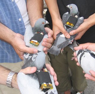
Some people have expressed concerns that wearing the "backpacks" might be stressful to the pigeons and also that the project is redundant because the EPA (Environmental Protection Agency) is already measuring pollution levels in the area. The group claims that the apparatus doesn't bother the pigeons (and most of the flights were a couple of hours at most in any case). In contrast to the EPA monitors, which are stationary, these birds were moving around while they collected data. From the maps on the site, it looks as if most of the birds staye fairly close to where they were released - so the results would be most useful for looking at spatial difference in pollution at a neighborhood level.
It all sounds kind of cool to me. I wonder if they looked at the pollution levels with respect to distance above the ground as well at latitude/longitude (the typical way to map dispersed pollutants) - I didn't see this on the site and don't know if it would yield interesting results or not.
PHOTO FROM THE PIGEONBLOG SITE
2 comments:
That's very cool. It would be cheaper if they just used people with asthma - where do they get wheezy? ;)
Haha, yeah, we'll put a GPS unit in your purse and get you to walk around Toronto on a smoggy day. We could put an attachment on an inhaler to monitor where, when, and how much medication you need, and get a subjective score from you about your level of wheeziness every five minutes.
Grad-school-itis is kicking in, I think.
Post a Comment